What a heat dome actually is
A heat dome is a big area of high pressure that parks over a region and acts like a lid. It traps hot air underneath, sinking air warms further as it is compressed, and clear skies let the sun bake the ground day after day. Because the system barely moves, the heat builds instead of breaking, and nights stay warm too, which is part of what makes it dangerous. Forecasters this week have described a pattern strong enough that some are calling it a double heat dome as it shifts and rebuilds. (CNN)
The timeline
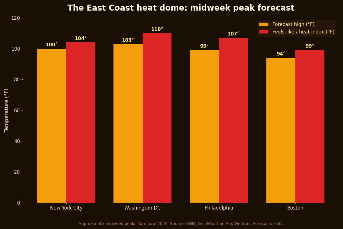
The heat built across the Midwest first, with temperatures in the 90s, and is spreading to the East Coast by midweek. That is when it will feel like 100 to 110 degrees for tens of millions of people, the region's most widespread heat wave of the summer so far. More than 100 daily record highs are possible through the end of the week. The relief comes around the holiday weekend, when a shift in the jet stream is expected to push the dome back toward the Plains and let cooler air and thunderstorms move in. Boston may cool before July 4, while Washington might not get a break until late on Independence Day or the Sunday after. (CBS News)
Why the feels-like number matters more
The temperature on your phone is the air temperature in the shade. The heat index, the feels-like number, adds humidity, and humidity is the real problem. Your body cools itself by sweating, and sweat works by evaporating. When the air is already thick with moisture, sweat evaporates poorly, so you keep the heat instead of shedding it. That is why a humid 95 can be more dangerous than a dry 100, and why forecasters this week are warning about heat indices up to 110, and as high as 115 in spots, with highs near 102 to 103 in Washington and around 100 in New York. (AccuWeather)
The warm nights are the hidden danger
The forecasts that worry meteorologists most are the overnight lows, with temperatures staying above 80 in some cities. Your body needs cooler nights to recover from the day's heat. When it never cools down, heat stress accumulates across days, which is why heat waves get more dangerous the longer they last, not less. This is especially hard on older adults, young children, people without air conditioning, and anyone working outside.
How to get through it
The basics are dull because they work. Drink water before you are thirsty, and do not wait for the dramatic symptoms. Stay out of the sun during the hottest stretch, roughly noon to early evening, and move hard activities to early morning. Find air conditioning, and if you do not have it at home, a library, mall, or public cooling center counts, even a few hours helps your body reset. Check on elderly neighbors and anyone who lives alone. And never, under any circumstances, leave a child or a pet in a parked car, where the temperature climbs to deadly levels within minutes even with the windows cracked.
Know the warning signs
Heat exhaustion looks like heavy sweating, cold and clammy skin, weakness, nausea, headache, and dizziness. The move there is to stop, get to a cooler place, loosen clothing, sip water, and cool down. Heat stroke is the emergency, and the tell is a change in the skin and mind, hot and often dry skin, a high body temperature, confusion, slurred speech, or fainting. That is a call-for-help situation, not a tough-it-out one. Move the person somewhere cool, use water and fans to bring the temperature down, and get emergency care right away.
Two dogs live in this house, so the next piece is the pet version of this guide, the heat dome and your dog, and the evergreen checklist is keeping pets safe in hot weather. You can see what this studio builds at jcmobileappstudio.com.
Comments
Be kind and stay on topic. Comments are reviewed before they appear.